-40%
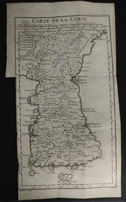
KOREAN PENINSULA 1750 G. DHEULAN UNUSUAL ANTIQUE ORIGINAL COPPER ENGRAVED MAP
$ 26.4
- Description
- Size Guide
Description
KOREAN PENINSULA 1750 G. DHEULAN UNUSUAL ANTIQUE ORIGINAL COPPER ENGRAVED MAPKOREAN PENINSULA 1750 G. DHEULAN UNUSUAL ANTIQUE ORIGINAL COPPER ENGRAVED MAP
Description
Carte de la Corée
.
Description:
Striking and highly detailed
fine unusual
the Peninsula of Korea based on D'Anville's map first issued in 1737. The map provides excellent topographic detail on cities, towns, rivers, roads, releifs and islands.
D'Anville's map was the first to focus only on the Peninsula and was based on the ground breaking surveys performed by the Jesuit missions to the Kangxi Emperor in the early 18th century. These missions sent back reports or the "Lettres Edifiantes et Curieuses" about the mysterious land of China. These were later edited and compiled into a work about the country issued by Jean Baptiste du Halde. A second edition of this work in 1737 was illustrated with a collection of maps compiled from these Jesuit surveys by Jean Baptiste d'Anville.
The reports about Korea were the first western source for the Peninsula and d'Anville's map was the first western map to focus on the Kingdom. It acted as a template for all 18th century maps of the country.
Date:
1750
( undated )
Dimension:
Paper size approx.:
cm 18,3 x 32,9
Condition:
Very strong and dark impression on good paper. Paper with chains. Map uncolored. Wide margin to the top. Wide lower margin. Small right lateral margin. Wide left lateral margin, partially missing to the bottom. Corners partially missing. Small foxing and browning. Map folded. Conditions are as you can see in the images
.
Mapmaker:
Jean Baptiste Bourguignon d'Anville (1697 - 1782) was perhaps the most important and prolific cartographer of the 18th century. D'Anville's passion for cartography manifested during his school years when he amused himself by composing maps for Latin texts. There is a preserved manuscript dating to 1712, Graecia Vetus, which may be his earliest surviving map - he was only 15 when he drew it. He would retain an interest in the cartography of antiquity throughout his long career and published numerous atlases to focusing on the ancient world. At twenty-two D'Anville, sponsored by the Duke of Orleans, was appointed Geographer to the King of France. As both a cartographer and a geographer, he instituted a reform in the general practice of cartography. Unlike most period cartographers, D'Anville did not rely exclusively on earlier maps to inform his work, rather he based his maps on intense study and research. His maps were thus the most accurate and comprehensive of his period - truly the first modern maps. Thomas Basset and Philip Porter write: "It was because of D'Anville's resolve to depict only those features which could be proven to be true that his maps are often said to represent a scientific reformation in cartography." (The Journal of African History, Vol. 32, No. 3 (1991), pp. 367-413). In 1754, when D'Anville turned 57 and had reached the height of his career, he was elected to the Academie des Inscriptions. Later, at 76, following the death of Philippe Buache, D'Anville was appointed to both of the coveted positions Buache held: Premier Geographe du Roi, and Adjoint-Geographer of the Academie des Sciences. During his long career D'Anville published some 211 maps as well as 78 treatises on geography. D'Anville's vast reference library, consisting of over 9000 volumes, was acquired by the French government in 1779 and became the basis of the Depot Geographique - though D'Anville retained physical possession his death in 1782. Remarkably almost all of D'Anville's maps were produced by his own hand. His published maps, most of which were engraved by Guillaume de la Haye, are known to be near exact reproductions of D'Anville' manuscripts. The borders as well as the decorative cartouche work present on many of his maps were produced by his brother Hubert-Francois Bourguignon Gravelot. The work of D'Anville thus marked a transitional point in the history of cartography and opened the way to the maps of English cartographers Cary, Thomson and Pinkerton in the early 19th century.
All of the maps we sell are ORIGINALS. We guarantee all of our maps to be authentic. We do our best to describe the condition of our maps as accurately as possible. Due to the age and type of paper, some imperfections are to be expected. Please examine the images provided carefully, and if you have any questions please ask and we will be happy to help.
A Certification of Authenticity ( COA ) can be issued on request
I will send you all your item by Registered and Insured Airmal or by TNT/DHL with covering Insurance
If you buy more than one item you have to pay just one only shipping cost
Any map purchased from us may be returend for any reason for a full refund.
About:
Old Times
Rare Antiquarian Books & Maps Sellers
Our Firm was founded in 1983 and we are specialized on antiquarian works on paper concerning Antique Rare Maps, Atlases and Travel Books of all the World.
Our Firm adheres to the Codes of Ethics outlined by the Italian Antiquarian Booksellers Association ( ALAI ) and International League of Antiquarian Booksellers ( ILAB ).
All items sold by OLD TIMES are genuine and a Certificate of Authenticity (COA) will be happily supplied on request.
Many Thanks
Cesare Giannelli
OLD TIMES
RARE ANTIQUARIAN BOOKS & MAPS SELLERS
Via Cortonese, 70
06124 - Perugia
Italy
Phone/Fax: 0039 - 075 - 505 20 18
http://www.oldtimesrarebooks.com
View My Feedback
View My Other Items For Sale
View My About Me page
Visit My eBay Store
Add me to your Favorite Sellers
Click images to enlarge
Pictures sell!
Auctiva offers Free Image Hosting and Editing.
300+
Listing Templates!
Auctiva gets you noticed!
The complete eBay Selling Solution.
Track Page Views With
Auctiva's FREE Counter


